CARTOMAP CAD app for iPhone and iPad
CARTOMAP CAD allows you to create, read, edit, send and receive DWG/DXF/CTM drawing files directly from your e-mail, iTunes or any WebDAV compatible storage, and provides you more than 150 CAD tools to consult and edit the files. New snaps to, rulers, grid and UCS makes easiest to draw. There is no need of Internet connection or additional applications: your project confidentiality is guaranteed.
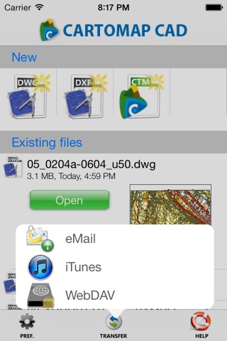
1. Send and receive DWG/DXF/CTM drawing files directly from e-mail, iTunes or any WebDAV compatible storage, with no need of additional applications.
2. Work from anywhere without requiring Internet connection.
3. Confidentiality and a total control of your projects.
4. File manager that allows you to create new projects, delete, rename, send/receive drawing files by email, iTunes or WebDAV.
5. More than 150 CAD tools that include edition of lines, arcs, circles, polylines, freehand, axis, texts, symbols, dimensions, rectangles, information query, zoom options, object selection, coordinates selection, UCS... Multiple object selection and tools (move/rotate, mirror, copy one time, in array rectangular or polar...).
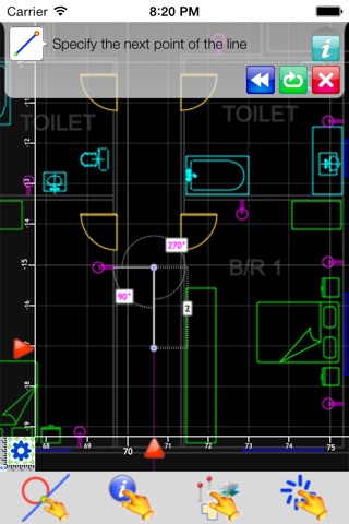
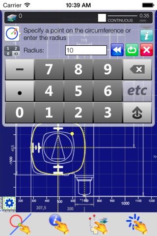
6. New objects can be drawn in different ways: by specifying points, by entering object analytical parameters (radius, angle, distance…) and by using existing elements as a reference (copy, parallel, chamfer, orthogonal…)
7. To modify drawing objects you can use the edition tools to move, cut, extend, rotate; insert, edit and delete vertices.
8. Point selection can be done using multiple options that can be selected by default or specifically for one action. Point selection options are: touch location, absolute coordinates or referred to a selected point, endpoints, intersections, proyected in an item, perpendicular to an item, curve center, midpoint...
9. SnapTo by orientation, length, point, endpoint, midpoint, intersection, grid...
10. Graphical tracking with magnifying glass, smart cursor and properties info.
11. Layer manager with preview, line type selection, color; visibility and lock status, etc.
12. Undo/redo with the historical actions of file modifications.
13. Linear and angular units can be selected by the user. CARTOMAP CAD alerts if the file units are not coincident with the units selected in preferences. X-Y-Z and North-East-Elevation coordinates system. Angular systems suitable to surveying and civil engineering.
14. Multiple views with independent zoom and layer visibility selection that makes easier to access to drawing details.
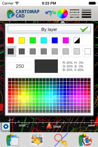
15. Layers and Views preview.
16. Color selection by color table (256 colors) or by true color. Background color can be selected for each view.
17. Selection of line type, line width, etc.
18. Multiple zoom options: zoom to a point or entity, move, zoom in, zoom out; these options are essential when using a pointer because it does not have multitouch.
19. DWG/DXF files supported from v.14 up to 2010. Some drawing objects are not supported (xref, paper-space, very complex hatches, some proxy without embedded geometry...) but they are maintained in the DWG/DXF file.
20. All screens and toolbars are prepared to be used on the iPad in layout or portrait mode, you can rotate the device at any time you need.
21. Unicode compliant: language as chinese, arabic, russian, etc, are supported.
22. Rulers can be shown or hidden, fixed or auto adjusted.
23. Grid can be shown or hidden, fixed or auto adjusted, with 3 levels of detail and lines selected by user. New snap-to grid to make easier to sketch.
24. Multiple User Coordinate Systems (UCS) by one or two points (moves and/or rotates the view). Info request and data entry can be done in UCS.
Pros and cons of CARTOMAP CAD app for iPhone and iPad
CARTOMAP CAD app good for
As soon as my iPad shows up, I believe this app will revolutionize the way I do my job.
Im excited to see this developed further. Id also like to see the file transfer simplified to a basic FTP interface.
I bought Cartomap shortly after it came out and was so excited I immediately tried to use it...and was disappointed. I contacted the developers and found them to be exceptionally helpful and willing to answer my questions and address the issues. I also READ THE INSTRUCTIONS! This helped me figure out that most of the issues I was having were my fault for expecting Cartomap to be AutoCAD, which it is not. Once I understood how they differed, I was able to use the program. The developers are continually adding new options, I am sure as they develop the program and receive feedback they will address the missing functions and issues. I am very glad that I took a chance on the program, I may never be able to do complete drawings on it, but it is a big time saver in my opinion. I have transferred several AutoCAD drawings in .dwg format to the program and they certainly are good enough to verify and show in the field. I look forward to the updates that will add text and dimensioning capabilities, and will comment on the exchange from Cartomap to AutoCAD soon.
Ok this app works great but you must go into it remembering... its not AutoCad! You will have to learn the controls how to draw lines... takes some getting used to. I sent them an email and ask about dimensions it will show them from your drawing if they are already there but it will be sometime in Nov before they update the app to make new ones from the app. I sent an email and got a quick responce from them so thats always good. The drawings are not native dxf so you need to make you a folder on your desktop and send them back and foward into it using the free desktop app.... its not hard to do. If you really want a cad app that is stand alone on your ipad and are willing to give it a small learning curve.... this is the app for you!
This is the best basic CAD program for the iPad. I have previously tried all the others I could find in the AppStore, but only this one comes close to my everyday PC CAD program -Intergraph Smartsketch. While at my workplace AutoCAD is the standard and I have training in it, Ive always found Smartsketch better for quick simple things like floor plans.
I took a chance with CARTOMAP CAD since it was $20 and had no reviews... but what a lucky strike! After about 30 minutes of playing around with it and not really looking at any instructions, I was productively making a plan of my bathroom remodel. While it takes some getting used to, most of the major features are there and work well.
The import feature leaves something to desire, which was originally what i was looking for, but there isnt a program Ive used so far on PC that can accurately import. My problem was I could not get a pre- made drawing to come in at the right scale, so none of the new work on the drawing in the program would be at the originals scale.
When making original drawings, this program is very intuitive, and the closest thing Ive found to the aforementioned Smartsketch. Especially handy is the snap function that lets you accurately pick points.
The only two problems so far (Im sure Ill find more with use) are :
1) I cant see how to print from the program. You can send a file via email, but it is still a dwg, dxf, or native format so unless you have another program that can print these formats (from the iPad) then you are stuck sending to a PC to print or doing a screen cap and printing as a photo from the iPad.
2) There is no area fill hatch function, so I cant show different materials or areas Id otherwise want to highlight.
Overall, I think future updates can only improve this great program.
Some bad moments
Unfortunately it crashes under iOS7. It is not possible to work with it, to load a file to change preferences and so forth. Please update this great app to be compatible with iOS7 and I give you all five stars!
App is poorly explained and there is little help. Menus are strange symbols with no explanation of what they are. The process of loading drawings in is cumbersome. It should be linked wirelessly to a remote server so the latest drawings from the office can be accessed. Having to load them back and forth with a cryptic program is just brutal. Option for black background color would be nice too.
Needs a lot of work. Not worth 20 bucks. 10 max
I want a decent cad reader that lets me load the latest drawings from my office while in the field!
This is what I was looking for! 80% of AutoCAD for an affordable price. But it seem I lost my money as it is always freezing when setting the view and grid. This, even if I rebooted.
I would like a (numeric?) keyboard to come up as soon as I touch to input precise coordinates/info.
App wont stay open. Everything I try to do it crashes the app.
I can not connect to the iPad. Developers please fix it soon. 20 USD.
This is the only dwg viewer I could find. I cant comment about this app on an ipad and so my comments are limited to the iPhone only. Ive been an architect for 15 years and I can say without hesitation or reservation the only use for this app is for field markups only and as I can see there are no such tools. To suggest someone would actually gain some benifit by producing cad drawings on a phone is frankly a joke. What I can see is loading a set of construction docs on the iPhone and have them with you for those unfortunate times when you need the reference and dont have a hard copy set at the site. You could then take measurments and digitally redline the drawings for later distribution. Come on guys get real and get these tools ASAP and Ill review again. Also I can only open 3 out of 40 ... Not good. All of our drawings apprear too large to open. Not to mention x-refs? Im assuming dawings would have to ne bound first to be viewed. Once thats done the drawing can not easily be reintoduced into the set. That means the only use is for markups. For me Ill keep this app closed until the next update and consider the 20 bucks a tiny gamble. Good luck to us all.